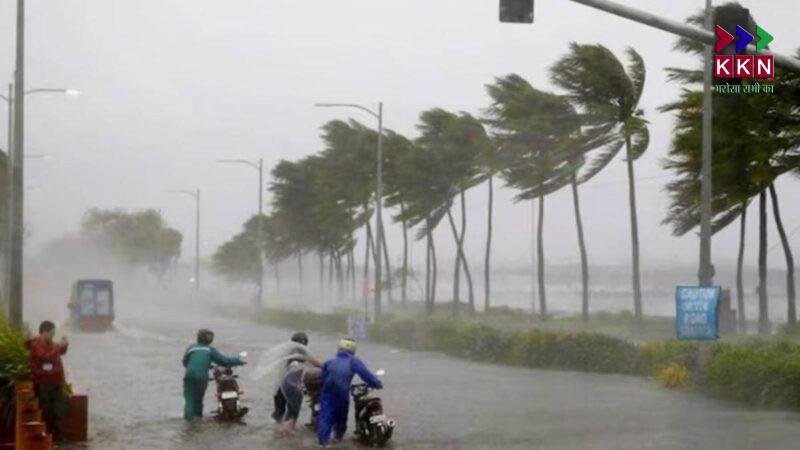
The monsoon is in full swing across Bihar, bringing widespread rainfall and raising concerns for the next two days. The India Meteorological Department (IMD) has issued an alert for several districts, warning of intense showers and possible flooding. Northern Bihar, in particular, is expected to experience heavy downpours, prompting the disaster management department to remain on high alert.
Monsoon Gains Strength Across Bihar
The monsoon system has become more active over the state. Since Sunday night, moderate rainfall has been recorded in several areas, including Patna, Supaul, Banka, and Lakhisarai. Early Monday morning, heavy showers began in Sitamarhi, Purnea, and Katihar, with some regions experiencing intense, continuous rainfall. Southern districts like Patna also reported overcast skies, with occasional spells of rain.
According to the IMD, fourteen districts in North Bihar will likely see heavy to very heavy rainfall today. Other parts of the state may experience light to moderate showers. However, the real concern lies in the forecast for August 12 and 13, when the entire state is expected to witness intense monsoon activity. The disaster management department has already taken precautionary measures, calling the situation a potential danger signal for the region.
Districts on High Alert for Heavy Rainfall
Today, several districts in North Bihar are bracing for heavy rain. These include Sitamarhi, Sheohar, Darbhanga, Madhubani, Supaul, Araria, Kishanganj, Purnea, and Katihar. In these areas, rainfall has been consistent since morning, disrupting daily life. Waterlogging has been reported in low-lying regions, and traffic movement has slowed in urban centers.
Other districts in the state are expected to receive light showers. However, overcast conditions persist, and the possibility of heavy rainfall in isolated pockets cannot be ruled out.
IMD Warning for August 12 and 13
Meteorologists predict that the current weather system will peak over the next two days. On August 12 and 13, heavy to very heavy rainfall is expected across the state. Northern Bihar’s 19 districts may also experience thunderstorms, accompanied by strong winds. Southern districts, including Patna, Gaya, and Nalanda, will likely see intermittent heavy showers during this period.
This intense rain pattern is linked to an active monsoon trough and favorable moisture conditions from the Bay of Bengal. Such conditions often trigger heavy rainfall events in Bihar during August.
Disaster Management on Standby
Bihar’s rivers, including the Ganga, have already breached danger marks in several locations. Floodwaters have entered villages and homes in multiple districts, affecting thousands of residents. Patna, Buxar, and Bhagalpur are among the most affected regions, along with several districts in North Bihar.
To manage the flood situation, 14 teams from the 9th Battalion of the National Disaster Response Force (NDRF) are on high alert. These teams have been strategically deployed: one in Darbhanga, one in Supaul, one in Motihari, and two in Nalanda. Additional teams are stationed in flood-prone districts to provide quick response and rescue operations.
Although some rivers have shown a slight decrease in water levels, officials remain cautious. The forecast of heavy rainfall over the next two days could reverse this trend and worsen flooding in vulnerable areas.
Current Situation in Flood-Hit Areas
Several districts are already reeling from the impact of continuous rainfall over the past week. In Bhagalpur, flooding has disrupted road connectivity, with National Highway 80 temporarily closed due to waterlogging. In Buxar, the Ganga’s water level has dropped slightly, but local authorities are monitoring the situation closely.
Residents in low-lying areas have been advised to move to safer locations. Relief centers have been set up, and emergency supplies of food, drinking water, and medicines are being distributed. Boats are being used to evacuate stranded families in areas where roads are submerged.
Public Advisory for Residents
The Bihar Disaster Management Department has urged residents to remain indoors during heavy rainfall. People living near rivers or in flood-prone zones have been asked to stay prepared for evacuation if necessary. Commuters are advised to avoid unnecessary travel, as waterlogging and poor visibility can make driving risky.
Citizens have also been encouraged to stay updated with official weather bulletins and not rely on unverified information. Local authorities are using social media platforms and community radio to share real-time updates.
Major Cities: Temperature and Air Quality
Despite the heavy rains, maximum temperatures in major cities remain in the low to mid-30s. Patna recorded a maximum temperature of 33.1°C and a minimum of 26.4°C, with an Air Quality Index (AQI) of 74. Muzaffarpur reported 31°C as the maximum and 27.1°C as the minimum, with an AQI of 56. Gaya registered 34.4°C as the maximum, 26°C as the minimum, and an AQI of 82. Purnea saw 34°C as the maximum and 27.5°C as the minimum, with an AQI of 55. Bhagalpur recorded 33.5°C as the maximum, 27.4°C as the minimum, and an AQI of 84.
Economic Impact of Heavy Rains
Heavy rains in Bihar have a significant impact on agriculture, transportation, and local businesses. Paddy fields in North Bihar are facing waterlogging, which can damage crops if conditions persist. Vegetable markets have also been affected, with supplies from rural areas slowing down due to poor road conditions. This has led to a rise in prices for certain fresh produce in urban markets.
The transport sector is under pressure, with several bus routes cancelled or delayed due to waterlogged roads. Train services in flood-affected areas have also been disrupted, causing inconvenience for passengers.
Historical Rainfall Patterns in August
Historically, August has been one of the wettest months in Bihar, with the state receiving a large share of its annual rainfall during this period. In recent years, however, extreme weather events have become more frequent, often leading to severe flooding. Experts link this to changing climate patterns, which are causing monsoons to become more erratic.
The IMD has been improving its forecasting techniques to provide timely alerts. Satellite imagery, Doppler radar, and advanced weather models are now being used to track rainfall patterns and predict flood risks with greater accuracy.
Preparedness Measures for the Coming Days
With the forecast indicating heavy rainfall, the state government has mobilized resources to minimize damage. Schools in vulnerable districts may remain closed if conditions worsen. Medical teams are on standby to handle potential outbreaks of waterborne diseases. Drinking water supply systems are being checked to prevent contamination from floodwaters.
Electricity boards are also taking precautions to avoid power outages caused by storms and falling trees. In flood-prone areas, temporary shelters with basic amenities have been established for displaced families.
The Role of Citizens in Mitigation
While government agencies are taking steps to prepare, citizen cooperation remains crucial. Avoiding dumping of waste in drainage systems can help prevent urban flooding. Timely reporting of breaches or waterlogging to authorities can speed up response efforts. Community participation in relief and rescue operations can also strengthen resilience during such disasters.
If the IMD forecast holds, Bihar is set to face challenging weather conditions over the next 48 hours. Residents, especially in northern districts, should remain alert and follow official advisories. Farmers may need to take preventive steps to protect standing crops. Authorities will continue to monitor the situation and take action as required.
As the state braces for this intense phase of the monsoon, preparedness and caution will be key to reducing the impact of the upcoming heavy rains.